The first two graphs below are from original Mogul records and show Flight #11 from July 7, 1947, and Flight #5 from June 5, 1947. Further down are two of Charles Moore's plots of Flights #4 & #5 showing how they have been changed. To help in locating landmarks, red grid marks have been added to plots where lacking. Mileage east and north of the launch site at Alamogordo AAF has also been added in red. In addition, all of the following graphs have been resized to the same scale to aid in comparison.
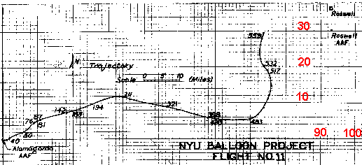
Note that in the Flight #11 graphic directly below, both Roswell base ("Roswell AAF") and Roswell town ("Roswell") are plotted on the map. Roswell base in this plot is shown as 93 miles east and 30 miles north of Alamogordo AAF.
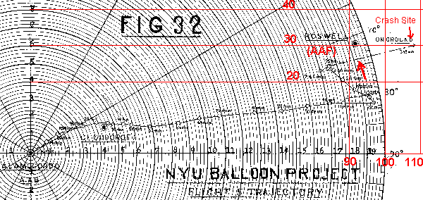
In the Flight #5 plot, only "Roswell" is shown, but this is not Roswell town but the base, again 30 miles north of the launch site (though shown only about 91.5 miles east instead of 93 miles)
Now note the following three locations on the plot above for Flight #5. First is the location of Roswell base itself. Second is the larger red arrow pointing to the closest approach of Flight #5 to Roswell AAF. See how it passed within about 4 miles of the base. Finally, the small arrow points to the crash site noted on this original graphic. It is only about 16 miles east of the base.
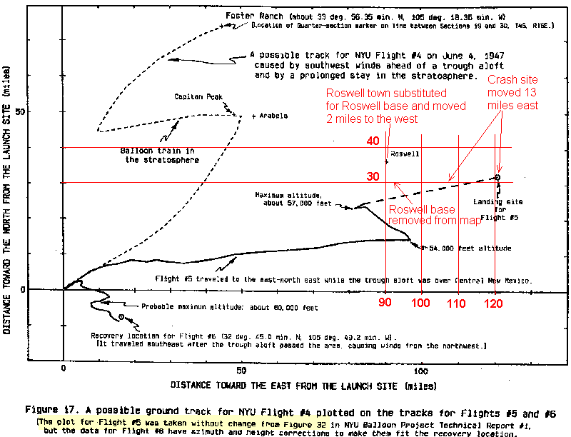
The next plot is Charles Moore's original Flight #4 trajectory plot from 1995 on which he also adds plots of Flights #5 and #6. In the legend beneath the plot, high-lighted in yellow, Moore wrote, "The plot for Flight #5 was taken without change from Figure 32...", i.e. the plot directly above.
Although Moore claimed he made no changes to this plot, he actually made three, as noted on the graph in red letters below. First, he removed Roswell base from the map. Now it is no longer obvious just how close the flight actually came to the base, as in the original graphic. In its place, he put "Roswell", but now meaning Roswell town instead of Roswell base, as the original Flight #5 graphic had it. Since Roswell town was 6 miles north of the base, this has the effect of seemingly increasing the distance between Flight #5 and "Roswell". Furthermore, Moore pushed Roswell town 2-3 miles further to the west than where the Flight #11 graphic above locates it.
And finally, Moore pushed the crash site 13 miles further to the east than the original Flight #5 plot. Moore now has the distance between "Roswell" and the crash site as 31 miles, instead of 16 miles in the original plot. By playing games with the graphic, he has also doubled the distance between "Roswell" and the crash site.
Moore also changed the original plot for Flight #6, altering azimuths and altitudes to get the crash location to square with the trajectory plot. Although these manipulations are questionable, at least Moore was direct in stating what he had done.
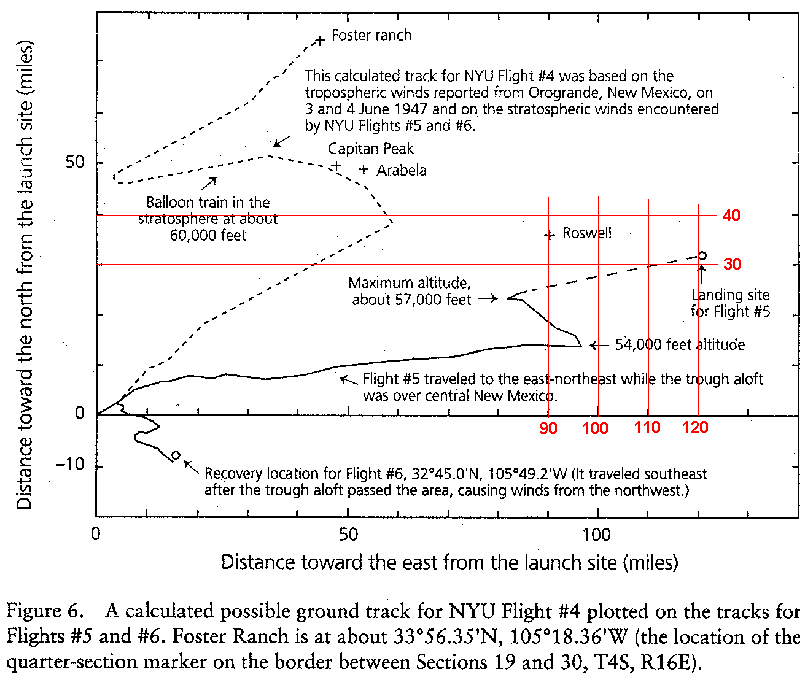
Below is Moore's revised Flight #4 trajectory from 1997. This was scanned from his book. Note that he has retained the exact same misleading altered graphic for Flight #5 that he had above from 1995. Roswell base has been removed from the map, Roswell town has been substituted further to the north and also mislocated to the west, and the crash site has been pushed to the same extreme location to the east. All of this seems deliberately done to remove Flight #5 as far from "Roswell", i.e. Roswell base, as possible.
Also note Moore's rather crude Flight #4 trajectory plot from 1995 above. It appears to be little more than a "seat-of-the-pants" freehand sketch rather than some careful calculation, as represented by the skeptics. Further note Moore's revised plot from 1997 below, based on more precise wind data, that shows the winds "curving" in the opposite direction from the way Moore had them in 1995. It seems Moore in 1995 mostly guessed winds that would have steered the balloons directly to his favorite landmarks of Capitan Peak and Arabela. The actual wind data had them blowing much more strongly to the east than Moore originally had them, creating a serious problem in his revised 1997 model in terms of getting them to the Foster ranch crash site. Hence his rather extreme assumptions and hidden data manipulations as detailed in the main text. Notice, e.g., the much more prolonged stay in the stratosphere in the 1997 model, causing Moore to ignore his conclusion from 1995 of a post-dawn launch, instead replacing it with a highly questionable late-night launch.