Where Did Mogul Balloons Crash?
Just how likely is it anyway that a Mogul balloon could explain the Roswell crash? Very low according to actual Mogul records. Prevailing winds blew them elsewhere.
Two graphics below, derived directly from Project Mogul records, show where the various Mogul balloons launched from Alamogordo, N.M. 1947-1949 eventually crashed. It is quite clear from these records that it was statistically unlikely for any hypothetical Mogul flight to actually end of up at the Foster Ranch debris field 85 miles North-northeast of Alamogordo and would have triggered the so-called Roswell Incident of early July, 1947.
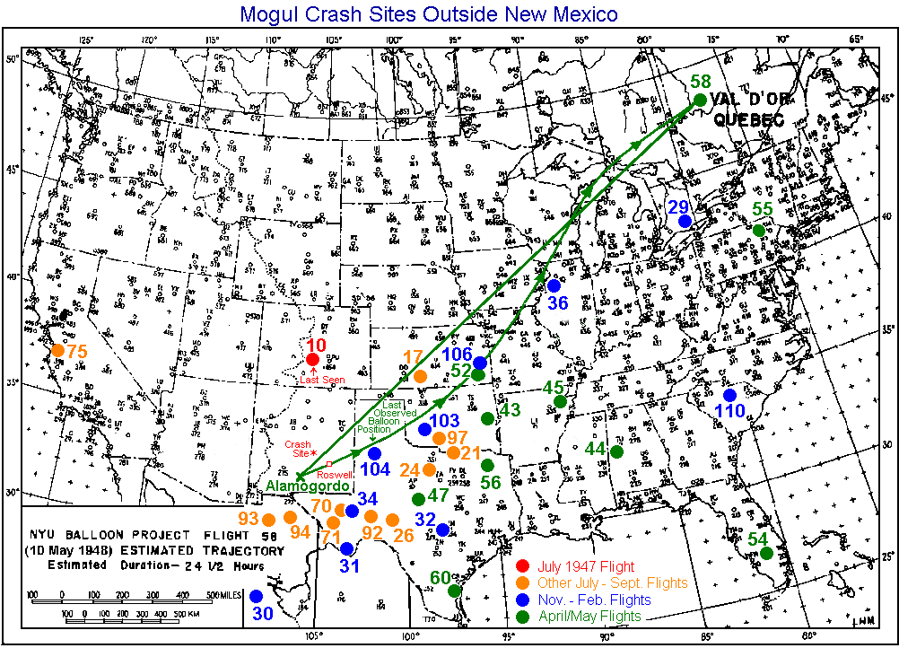
52 recorded balloon flights from Project Mogul are plotted, 32 of which crashed outside of N.M. and 20 within. (New Mexico plot; USA plot)
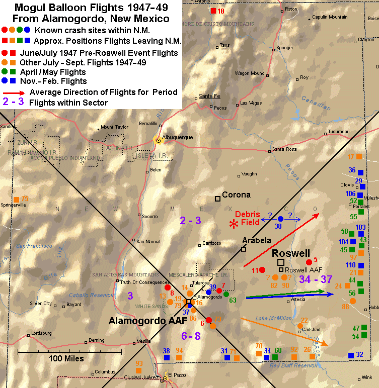
As the first plot of New Mexico demonstrates, prevailing winds took about two-thirds (34-37) of these flights in the direction of Roswell through the Eastern sector from Alamagordo. Flights that crashed within N.M. are plotted as circles, and those that left the state as squares, with their approximate position as they left the state (usually based on eventual crash site).
6-8 flights passed through the Southern sector and 3 passed through the Western sector, perhaps 2 or 3 into the Northern sector (i.e., roughly in the direction of the Foster Ranch), and the remainder crashed very near Alamogordo with no clear directional bias. Of the 20 N.M. crashed Moguls, 13 crashed within about 30 miles of Alamogordo and 4 within 20 miles of Roswell town and base, 90+ miles to the East-northeast. 30 out of 32 balloons that passed out of the state went east or south.
Thus the Foster Ranch was well off the beaten path. Prevailing winds took the flights in a different direction about 95% of the time and none are documented as crashing near there.
Winds for June 4, 1947, were also wrong to take a balloon from Alamogordo to the debris field site. Nonetheless the Air Force and Mogul engineer Charles Moore tried to make it case that a totally undocumented balloon launch on this date was the Roswell crash object. Moore also created a hoaxed trajectory to take this imaginary balloon "exactly" to the Foster Ranch crash site, claiming the winds were "exactly right." In reality, the winds were too strong and too easterly. See above links dissecting Moore's hoaxed Mogul trajectory and redone calculations showing where any balloon, if it existed, would likely have ended up given the actual winds.
As can been seen on the plot below, there is only one flight, #38, Nov. 4, 1947, that may have crashed anywhere near the Foster Ranch. It was noted in records as crashing about 50 miles North of Roswell, but the exact position wasn't known (the chase plane couldn't find the final site). If it was due north, this still would have left it about 40 miles east of the debris field. Even if we assume 20 miles East/West uncertainty (arrows), the balloon would have ended up no closer than 20 miles away.
The next "closest" was Flight #11, which crashed a dozen miles west of Roswell AAF, or still around 60 miles away from the debris field.
Flight #14, one of the balloons listed here as flying into critical Northern sector, barely went 10 miles from Alamogordo before crashing. Only Flight #10, July 5, 1947, and Flight #17, Sept. 10, 1947, passed in a direction that took them anywhere near the debris field, perhaps within 20 miles. But they stayed aloft and eventually left the state. Flight #10 lacks a trajectory plot, but was seen near Albuquerque and last seen in Colorado, thus its likely trajectory was about due North. Flight #17 ended up in Kansas and has a precise trajectory plot during its initial flight in N.M. It flew in a straight line along the Northeast diagonal over the small town of Arabela before they lost the track.
The second graphic shows the 32 crash sites outside of N.M. The Northeast diagonal from Alamogordo (green line) shows that 30 of the 32 balloons went east or south. Only one went North (#10) and only one went West (#75). The latter was deliberately lofted to very high altitudes to catch winds to the West and crashed in California.